About New Sudbury Days
First held in 2015, New Sudbury Days is a celebration of our local New Sudbury community and all it has to offer to residents, and to property and business owners. Initially, the organizing team organized events in Ward 8, Ward 11 and Ward 12, but the festival went on hiatus for 2 years during the covid pandemic, returning in 2022 as a smaller festival held only in Ward 8. In 2023, it is now up and roaring again with events being planned in all 4 wards.
Usually held the last weekend of August, events are held at local parks, local businesses, and other venues. Events are free of charge and are generally geared towards healthy family fun.
2024 Organizing Team
Julie Labre, Co-Chair
Rachelle Niemela, Co-Chair
Patrick McCoy, Treasurer and Lead-Donations, Sponsorships and Grants
Serge Sauve, Lead-Performers & Entertainment
Caitlin Buck, Westmount & Social Media
John Fraser, Co-Lead Vendors
Spenser McCall, Lead-Communications, Advertising, and Public Relations
Jacob Sintic, Lead-Volunteers
James Pollesel, Fundraising & Sponsorships
Al Sizer, Co-Lead, Vendors
Karan Bhadesha
Venue/Event Leads
Downe Park: Shannon Labre
McLean Park: Julie Labre
Place Hurtubise Park: Renée Barbeau-King and Ashley Greenlaw
Ridgecrest Park: Julie Labre
Twin Forks Park: Rachelle Niemela and Patrick McCoy
Westmount Park: Mary Morrier
Bowling Tournament: Patrick McCoy
Supporting City Councillors
Joscelyne Landry-Altmann (Ward 12)
Bill Leduc (Ward 11)
Mike Parent (Ward 5)
Al Sizer (Ward 8)
Partners
Downe Neighbourhood Association
Place Hurtubise & Keewatin Crt Tenant Association
Twin Forks Neighbourhood Association
Westmount Neighbourhood Association
About the New Sudbury Neighbourhood
New Sudbury, formerly called the North End of McKim and Neelon Township, is situated north of Wilma Street along Notre-Dame Avenue and south of McCrea Heights, near the Maley Drive extension. It stretches west to Frood Road and east to approximately eleven kilometres before Coniston, and south to include the north side of the Kingsway, up to where the old city limits arch stood on the Kingsway (a few feet west of where Laking Toyota is now situated).
Initially bush in the 1880s, it became the site of a prosperous lumbering industry in 1888. With the railroad coming to Sudbury circa 1883, pioneer farming families came from Québec, southern Ontario, and parts of Europe. Farms were located along Garson Road (Lasalle Boulevard), from Maley Drive in the north and up to Capreol Road (Notre-Dame Avenue) in the west.
With the mining industry rapidly growing in the early 1920s and 1930s, emissions produced by the industry’s roasting beds made farming more difficult and eventually impossible. Eventually, the farmers sold their properties to developers, and by the 1950s and 1960s, New Sudbury become home to many residences, schools, churches and commercial enterprises, including the New Sudbury Shopping Centre which opened in 1957. In 1949, the area was renamed New Sudbury. In the 1960 amalgamation, Sudbury became a city of 75,000 people, absorbing the residents of McKim Township, the west half of Neelon Township, and Frood and Stobie.
From: New Sudbury Not As New As You Think, A community history, 2015 by Arthemise Camirand-Peterson, President of the New Sudbury Historical Society, former Chair of the Ward 12 New Sudbury Community Action Network and founding member of New Sudbury Days. Also Jason Marcon (via a Facebook post) for the location of the Kingsway arch.
New Sudbury now encompasses parts of Ward 5, Ward 8, Ward 11 and Ward 12 of the City of Greater Sudbury. This community is home to the Adanac Ski Hill, Rotary Park, the Nickeldale Moraine, Timberwolf Golf Course, Cambrian College, shopping malls and a multicultural, vibrant community of over 24,000 people. The area also includes the smaller neighbourhoods of Nickeldale, Barry Downe, Don Lita and Lebel.
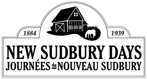
The New Sudbury Days Logo
Our logo is based on the street sign toppers that are installed throughout the New Sudbury neighbourhood. The toppers preserve our historical heritage, identify our Greater Sudbury neighbourhood, and help to beautify our well-traveled roads. The logo, which shows a barn and horse, notes the dates 1883 to 1939 – the farming era in the townships now known as New Sudbury. Thank you to Pam Nelson Designs for generously providing us with this logo.
In 2013, the Ward 12 New Sudbury Community Action Network, in partnership with the New Sudbury Historical Society/Societé Historique du Nouveau Sudbury, began a project to design and install toppers on street signs in New Sudbury. This project was based on the work done by the Uptown Community Action Network who installed street sign toppers in their downtown Sudbury neighbourhood. In January 2014, the New Sudbury Historical Society worked with local high school principals to give a presentation and history lesson to local grade 7 and 8 students. The students were asked to submit designs for the toppers with the theme of highlighting the farming history of the area.
Three of the best designs were chosen by members of the Historical Society from each school with four of the five school submitting entries. The twelve designs were on display at the New Sudbury Shopping Centre for one week for a public vote. Hannah Villeneuve, a grade 8 student from MacDonald Cartier, was the winner by a large majority. The design is featured on over 80 street sign toppers installed in the New Sudbury area.